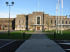
Romford
Romford is a large suburban town in northeast London,[2] England and the administrative headquarters of the London Borough of Havering. It is located 14.1 miles (22.7 km) northeast of Charing Cross and is one of the major metropolitan centres identified in the London Plan.[3] It was historically a market town in the county of Essex[4] and formed the administrative centre of the liberty of Havering, until it was dissolved in 1892.[5] Good road links and the opening of the railway station in 1839 were key to the development of the town[4] and the economic history of Romford is underpinned by a shift from agriculture to light industry and more recently to retail and commerce.[4] As part of the suburban growth of London in the 20th century, Romford significantly expanded and increased in population,[6] becoming a municipal borough in 1937[7] and has formed part of Greater London since 1965.[8] It now forms one of the largest commercial, retail, entertainment and leisure districts outside central London[1] and has a developed night time economy.Toponymy Romford is first recorded in 1177 as Romfort, which is formed from Old English 'rum' and 'ford' and means "the wide or spacious ford".[11] The naming of the River Rom is a local 'back-formation' from the name of the town; and the river is elsewhere known as the Beam. The ford most likely existed on the main London to Colchester road where it crossed that river.[11] [edit]Economic development The town developed in the Middle Ages on the main road to London and the regionally significant Romford Market was established in 1247.[4] The early history of Romford and the immediate area is agricultural and it is recorded as being the location of a number of mills used to grind corn.[4] The area was a focus of the leather industry from the 15th to the early 19th centuries and there is record o
a wide range of industries such as cloth making, weaving, charcoal burning, metal working and brewing.[4] Communications played an important part in its development; the main road to London was maintained by the Middlesex and Essex Turnpike Trust from 1721 and Romford became a coaching town in the 18th century.[12] Several failed attempts were made in the early 19th century to connect the town to the Thames via a Romford Canal. Initially intended to transport agricultural products to London and later intended to serve growing industrial sites in Romford, only two miles of canal were constructed and the canal company were unable to reach the town.[13] The development of the town was accelerated by the opening of the railway station in 1839 which stimulated the local economy and was key to the development of the Star Brewery. Initially Eastern Counties Railway services operated between Mile End and Romford, with extensions to Brentwood and to Shoreditch in 1840. A second station was opened on South Street in 1892 by the London, Tilbury and Southend Railway on the line to Upminster and Grays, giving Romford a rail connection to Tilbury Docks. The two stations were combined into one in 1934.[12] Light industry slowly developed, reaching a peak in the 1970s with a number of factories on the edge of town, such as the Roneo Vickers office machinery company, Colvern manufacturers of wireless components, May's Sheet Metal Works and brush manufacturers Betterware.[4] Suburban expansion increased the population and reinforced Romford's position as a significant regional town centre. The Liberty Shopping Centre was constructed in the 1960s and has been recently modernised and supplemented with further shopping centres throughout the town, including The Mall, opened in 2006; and The Brewery, opened in 2000 on the site of the old Star Brewery.